
A new map of COVID-19 hotspots in Canada shows that so many more places are considered to have high rates of infection now.
Updated data and modelling was released by the Public Health Agency of Canada on November 20.
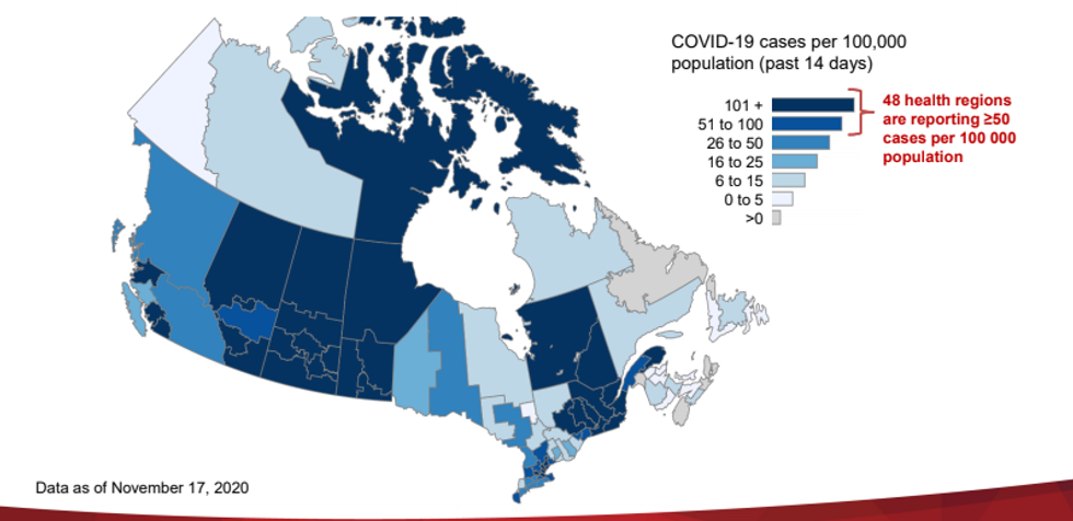
They've also released a map showing health regions across the country. The map is colour coded based on the rates of COVID-19 cases over the last two weeks and a lot more places have a higher rate now.
Editor's Choice: Ontario's New COVID-19 Restrictions Could Shut Down Hair Salons & Gyms By Next Week
 The Public Health Agency of Canada
As of November 17, 48 health regions reported more than 50 cases of COVID-19 per 100,000 people in the previous 14 days.
That's nine more than was reported in the last data and modelling update at the end of October.
During a press conference, Dr. Theresa Tam said this indicates "that the virus is spreading across a wider geographic area within Canada."
All health regions in Saskatchewan and Manitoba reported more than 100 COVID-19 cases per 100,000 people during that time.
Nunavut is also in the deepest shade of blue.
"Nova Scotia is another area of concern," Dr. Tam said.
That's because recent confirmed cases can't be linked to other known cases and is a sign that COVID-19 is spreading undetected there.
The new modelling forecasted that Canada could see over 20,000 daily cases by the end of December if changes aren't made.