
It might be time to grab a sweater! Ontario fall weather is on its way and we could see it as early as next week. This weekend, a “battle zone” of weather patterns are set to take over the province.
Ontario is going to be rocked by 80-km/h winds and rain today, so you’re going to want firmly to grasp your umbrellas.
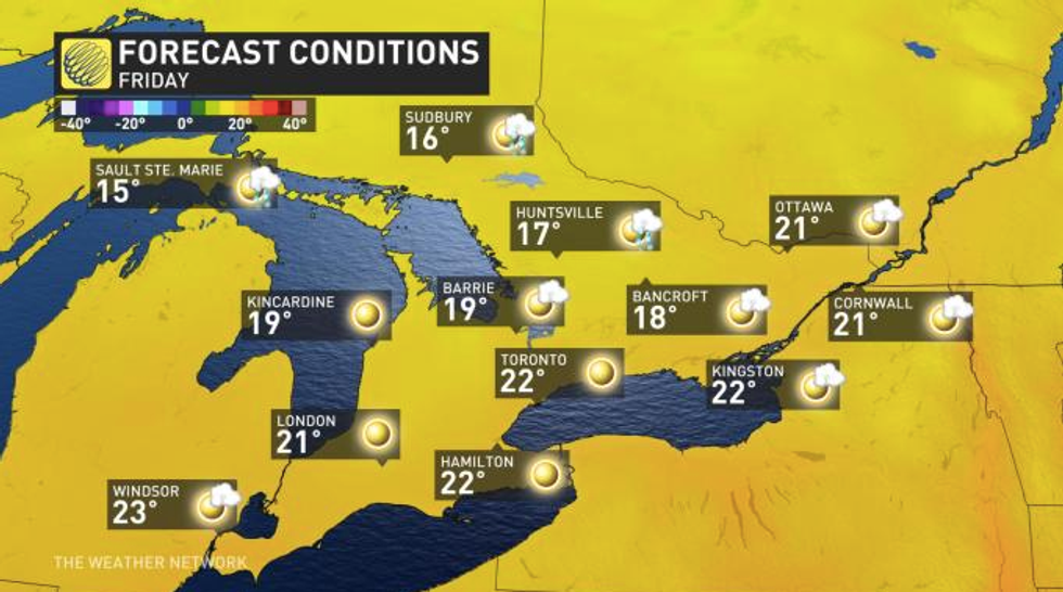
According to The Weather Network (TWN), an approaching cold front is forecast to wipe out any remaining humidity on Thursday.
Editor's Choice: A Positive Case Of COVID-19 Was Just Reported At A Winners Near Toronto
The sudden shift in temperature will create an ideal environment for thunderstorms and other nasty weather before the cooler air settles in on Friday.
It’ll be a cool morning for much of southern Ontario, with temperatures floating in the high teens.
However, don't bust out your best autumn attire yet as things are going to heat up late in the day peaking at 27 C.
As for what the weather will look like during the long weekend, that’s where things get tricky.
 The Weather Network
At the moment, Labour Day could swing one of two ways due to an incoming “strong cold front” that will either stall or bring about some chilly temperatures.
According to TWN, this weather will be a "battle zone" between hot and cold.
"The spread in the models is 15-20 degrees for the middle of next week. Our current forecast is a conservative compromise until confidence increases as to whether the heat or the chilly weather will win out," TWN meteorologist Dr. Doug Gillham reports.
This uncertain weather will also make for some wet and rainy days through the back to school period as well.
Turbulent weather has been the name of the game in Ontario this week.
The province had previously faced strong winds and potential tornadoes on Wednesday.