
It's time to bundle up. Ontario's weather forecast will be the coldest day since spring this Tuesday with temperatures as low as 14 C in parts of the province. The early taste of fall is set to bring sweater weather to the south for the first time in months, but it won't last.
According to The Weather Network (TWN), southern Ontarians are in for another "volatile" week as inconsistent temperatures create a potential atmosphere for severe storms.
Nothing too vicious is on the horizon yet, but experts are warning to be on the watch for weather alerts.
Editor's Choice: An Ontario Casting Call Will Pay You Up To $300 A Day To Star In A Haunted Television Show
Northern regions are going to face much cooler daytime temperatures than their southern counterparts this week.
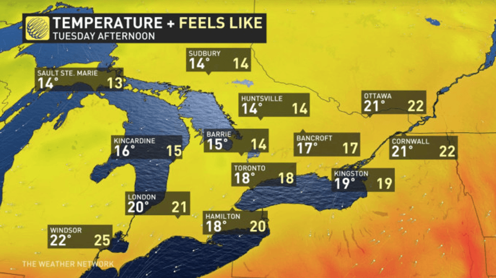
Areas such as Sault Ste. Marie and Sudbury could be as cold as 14 C, which is chilly enough to make anyone want to bust out a sweater.
However, southern Ontario will also be facing a break from the sweltering heat.
Areas in the GTA can see temperatures around 18 C, which is much cooler than the blistering heatwaves we have dealt with all summer long.
 The Weather Network
Heavy rainfall is also possible for areas like Toronto, Hamilton and London on Tuesday.
However, the cold won't last for long as temperatures are expected to feel like 32 C in Hamilton and in the mid to upper 20s in other parts of southern Ontario on Wednesday.
"That cooldown will be short-lived, with temperatures shooting back up into the mid to upper 20s Wednesday, feeling like the low 30s with the humidity," TWN states.
"But that warmth won't reach the north, some parts of which will be no warmer than the single digits, with a very sharp boundary between fall-like chill and temperatures better suited to mid-summer," it adds.
Southern Ontarians will need to stay updated on their forecasts as temperatures are expected to shift from heat waves to cooldowns several times this week.