8 Ontario Hikes Along The Bruce Trail To Explore For Epic Views & Adventure
Views for days. 🤩
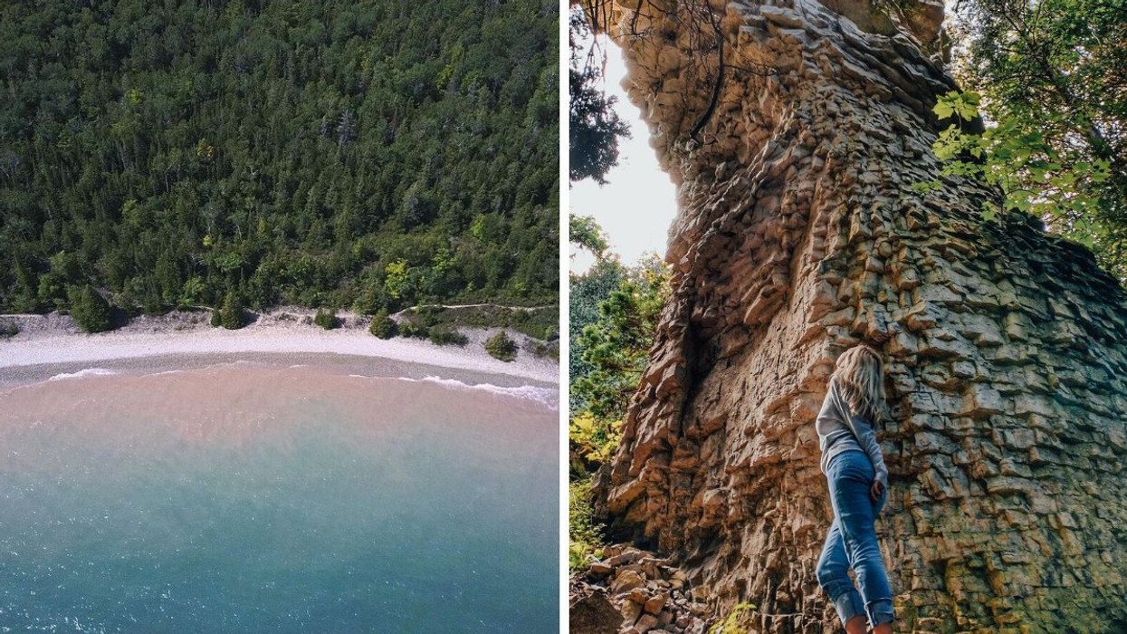
Smokey Head White Bluffs Nature Reserve. Right: A person at Devil's Monument.
Calling all nature enthusiasts! If you're looking for hikes that take you through rugged terrains, lush forests and jaw-dropping vistas, look no further than this iconic trail in Ontario.
The Bruce Trail is the oldest and longest marked hiking trail in Canada, covering 840 kilometres and offering over 280 trailheads just waiting to be explored.
Spanning from Queenston north of Niagara Falls all the way to Tobermory, the trail includes tons of stunning natural features, like waterfalls and valleys, as well as breathtaking vistas.
While it would be challenging to say the least to try to tackle the entire trail, there are a number of short trails along the Bruce that make for easy day trip activities.
From majestic waterfall hikes to trails leading to towering lookout points, here are eight hikes along the Bruce Trail to explore.
White Bluff
Price: Free admission
Address: 54 Forty Hills Rd, Lion's Head, ON
Why You Need To Go: Located in Lion's Head within the Smokey Head White Bluffs Nature Reserve, White Bluff is a landmark of the area, featuring a towering cliff topped with white rock and forest.
Visitors can hike three different loop trails along the White Bluff Loop that range from 2 to 4 hours in length and offer breathtaking views of Isthmus Bay.
According to Visit Lion's Head, this trail is a great one for beginners as the terrain is less steep. The White Bluff Loop can be found on Forty Hills Road, where you can park your car and follow the signs to find the trail.
Tew Falls
Price: $16 per vehicle and driver
Address: 607 Harvest Rd., Dundas, ON
Why You Need To Go: In Dundas, you'll find many different waterfalls along the Bruce Trail and its side trails, including the stunning Tew Falls.
Found within the Spencer Gorge Conservation Area in Hamilton, Tew Falls is a towering 41-metre-high waterfall, which is just a few metres short of Niagara Falls.
The ribbon waterfall is actually the tallest in Hamilton. It also marks the beginning of a forested hike toward Hamilton's famous Dundas Peak, where you can get incredible views of the valley.
Belfountain Conservation Area
Price: $7 per adult
Address: 819 Forks of the Credit Rd., Caledon, ON
Why You Need To Go: Belfountain Conservation Area has it all. About an hour from Toronto, you'll find lookout points, a suspension bridge, a beautiful waterfall, limestone cliffs, a historic fountain, riverside walks and more.
There are multiple hiking trails in the area with varying degrees of difficulty. The Trimble Side Trail is a "strenuous" side trail of the Bruce Trail that runs along the steep slopes of the West Credit River Valley to the Forks of the Credit, while the Gorge Trail, a "difficult" trek, takes you up the steep river valley and through Niagara Escarpment outcrops.
For easier hikes, there's also the Riverside Trail, a boardwalk trail taking hikers to scenic lookouts, and the Bide-A-Wee Trail, as well as multiple accessible paths.
Accessibility: Some wheelchair/stroller-accessible paths in the park.
Bruce's Caves Conservation Area
Address: Gray Rd. 1, Wiarton, ON
Why You Need To Go: In Wiarton, Bruce's Caves consists of seven hectares of Niagara Escarpment, caves and wooded swamp.
Here, you'll find unique cave formations created thousands of years ago by the wave action of post-glacial Lake Algonquin, according to Explore The Bruce.
It's a short hike to the caves, taking about 44 minutes to complete, according to All Trails. The path will take you right to the mouth of a cave with a central pillar at the entrance.
Spirit Rock Conservation Area
Price: $10 parking fee
Address: 92 Hwy. 6, Wiarton, ON
Why You Need To Go: This easy loop trail takes hikers past crumbling ruins and to a picturesque shoreline.
The ruins of Corran, a 17-room mansion once outfitted with ancient weapons, tapestries and book-lined walls, can be found here.
You'll definitely want to remember to pack a camera, as the trail delivers specatuclar views from the top of the Niagara Escparpment.
Before leaving, be sure to take the spiral staircase that leads down to a rocky shore with vibrant blue waters.
Lion's Head Lookout
Price: Free admission
Address: McCurdy Drive Parkette, Lion's Head, ON
Why You Need To Go: For some of the best views on the Bruce trail, look no further than this forested hike that leads you to an incredible lookout.
The Lion's Head Lookout trail is a moderately challenging out-and-back hike that takes just under 2 hours to complete, according to All Trails.
The trail has two loops, the main trail and inland trail, for a total of about 18 kilometres, according to Visit Lion's Head. While the trails are well marked, some parts can be a bit challenging, with crags, sinkholes, and no handrails.
However, the payoff seems to be worth it. The trail leads to a lookout spot where you can get gorgeous views of the aquamarine water and see Cape Dundas and Barrier Island as well as the cliffs of White Bluff, Cape Chin, and Cabot Head on a clear day.
Limehouse Conservation Area
Price: Free admission
Address: 12169 Fifth Line, Limehouse, ON
Why You Need To Go: Located in the Niagara Escarpment, Limehouse Conservation Area offers multiple hiking trails, including both difficult and easy treks.
Here, you can travel along the Bruce Trail to reach the “Hole-in-the-Wall," an area where a ladder leads to cracks in the escarpment rock that you can spend some time exploring.
The trail continues to the old Toronto Suburban Radial Railway before crossing over Black Creek on a bridge near the remains of an old mill.
The hike takes about 30 minutes to complete. For an easier journey, you can also travel along the Black Creek Side Trail, which follows the clear waters of the creek and takes hikers through different types of forests found along the escarpment.
Devil’s Monument
Price: Free admission
Address: 163 Borchardt Rd., Dyer's Bay, ON
Why You Need To Go: Devil’s Monument is the largest of the Bruce Peninsula's flowerpot formations. Here, you'll find spectacular scenery, and you can even bring along your furry friend.
The 4.2-kilometre loop trail is considered to be a moderate route — while the journey is fairly short, the access trail is steep, rocky and slippery, according to Visit Tobermory, so you'll want to have sturdy footwear and might even consider a walking stick.
The route takes just over an hour to complete, according to All Trails. You can take the trail and stairs down to a gorgeous rocky beach with shallow water that warms up in the summer. The beach makes for a great picnic spot or a place to swim (so be sure to bring a bathing suit and swim shoes).
Before you get going, check out our Responsible Travel Guide so you can be informed, be safe, be smart, and most of all, be respectful on your adventure.