Canada Weather Expert Says Ontario Storm Was 'Very Nasty' & There Were Some Signs
Ominous clouds and zephyr winds spelled disaster.
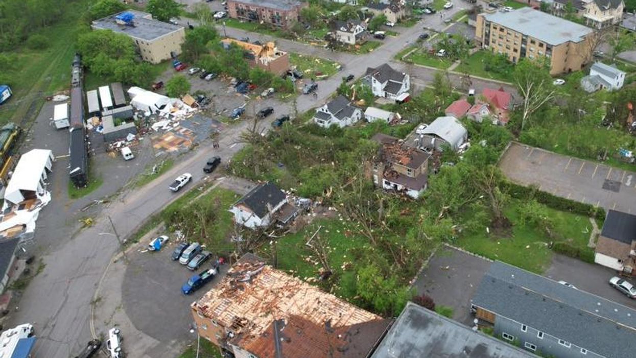
Damage caused by the derecho storm.
Canada's top climatologist says that the derecho storm that hit Ontario and Quebec on Saturday, May 21 was "a very nasty kind of storm."
The storm knocked out power to more than 1 million hydro users throughout the country and caused at least 10 deaths. It swept through Sarnia, travelling faster than highway speeds into Ottawa and Quebec.
According to a weather summary by the federal government, the Ottawa Airport saw winds as high as 120 km/hr on Saturday. The summary adds that there was severe damage to trees, power lines and buildings.
David Phillips, senior climatologist for Environment Canada, told Narcity that the sheer area and ground covered by the storm is what will make it distinct from others.
"The fact that it covered over an extensive area of geography made it somewhat significant — where instead of just covering a certain region, it covered, really, almost the entire southern and central part of the province."
Temperatures also rapidly changed throughout the day. In Ottawa, the weather shifted from 30 C to around 17 C in an hour's time. Although climatologists can't typically predict tornadoes, Phillips said the forecasted conditions were a perfect storm for severe weather including extreme winds.
"We knew was going to be an active kind of a day with summer heat and humidity and a coming cold front that would change everything," he said.
Phillips went on to say that the storm was "almost a chorus line, all with severe thunderstorms and powerful winds and rain and some hail, but winds were really the common denominator."
Although the derecho winds didn't reach as high speeds as previous tornados that have reached 210 km/h, Phillips said that the latest storm made up for that in its scale.
"This one was like 600 to 1,000 kilometres long and about 100 kilometres wide. So, it was just a gigantic kind of feature that just mowed down the province from one end to the other."
Signs of a severe storm on Saturday
Phillips added that it's difficult to predict how severe a storm will be until the "whites of the eye of the storm" can be seen.
"We do a good job of forecasting the conditions that will produce these kinds of major storms. But in the end, you can't necessarily forecast tornado."
On May 21, Environment and Climate Change Canada sent out a severe thunderstorm watch that reached most regions by 11:30 a.m. Canada's emergency warning system Alert Ready then issued a warning to mobile phones shortly after noon once winds reached 130 km/hr in Kitchener, Ontario.
Saturday's storm was the first time that a severe thunderstorm warning was broadcast immediately by Alert Ready.
"The amount of lead time a person would have received would depend on where they were located and how they were receiving the alerts," a representative for Environment and Climate Change Canada told Narcity by email. The government agency added that once experts can identify areas threatened by severe weather, they can give people about an hour or less of warning time.
ECCC says that notices are given so people can pay close attention to the potential rapid arrival of severe weather.
"I've never seen a derecho forecast. They're not that common. But they do occur in Ontario and the Great Lakes area from April through to June [...] when you've got warm air and cold air duking it out," said Phillips.
However, Phillips added that when looking at the sky on Saturday, you could see some menacing signs of the impending storm.
"There were ominous signs and clouds," he said. "There were distant thunder and lightning, there was rain, there were those little zephyr winds that turned into strong breezes. You knew that something was coming."
Weather experts are currently researching to see if the derecho contained any tornadoes.
Western University's Northern Tornadoes Project surveyed southern Ottawa and said the region saw a "particularly intense downburst" with winds reaching 190 km/h. They classified the damage as strong at EF2 on the Enhanced Fujita scale.
- Someone Has Died In Brampton After Being Struck By A Tree ... ›
- A Wild Storm Is Rolling Through Ontario & The Videos Are Terrifying ›
- Ontario's Weather Forecast Predicts A Gross Mix Of Hail, Rain & Thunderstorms For 2 Days - Narcity ›
- Ottawa's Weather Might Get 'Severe' Thunderstorms & It Could Stall Power Repair - Narcity ›
- Ottawa's Weather Is Set To Get Steamy This Week Before Plummeting To Cooler Temps - Narcity ›
- Coyote Hung Out Poolside During A Power Outage In Ottawa & It Started A Meme (PHOTOS) - Narcity ›
- Ottawa's Weather Is Under Severe Storm Watch & There's A 'Likely Tornado' Threat - Narcity ›
- Ontario's Storm Hit This Town So Hard That Some Roofs Were Blown Right Off (PHOTOS) - Narcity ›
- Ontario Power Outage Hit Over 200K People After The Storm & Some Are Still Without Power - Narcity ›
- Ottawa's Weather Feels like 34 C & There's Another Thunderstorm Watch With Possible Floods - Narcity ›