
We are in for some messy Ontario weather this week. The southern part of the province will be hit with the leftovers of a tropical storm which will bring everything from hail to severe thunderstorms. Ontario's weather forecast is even warning of the possibility of tornadoes.
According to The Weather Network, remnants of Hurricane Cristobal will wreak havoc on Ontario this Wednesday.
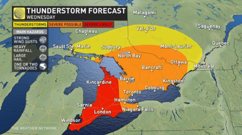
Severe thunderstorm warnings are already sweeping across southern and central regions of the province with powerful wind gusts, heavy rain and large hail expected to land today.
Winds could hit up to 100 kilometres an hour in the southwestern area of the province.
High-risk areas for the storm include Windsor, Sarnia, and London. A tornado or two is even expected throughout the day.
However, the GTA also has the slight possibility to be hit with severe thunderstorms throughout the day.
Meanwhile, a sudden rise in temperature is also makings its way across the province.
It will feel so muggy that several parts of the province are under heat warning where temperatures could reach into the upper 30s.
“Temperatures today will reach 30 or 31 degrees Celsius across the region in a hot and humid tropical air mass. Humidex values will reach the upper thirties to near 40 this afternoon,” a statement from Environment Canada reads.
Most of us already missed out on the first wave of rain and thunderstorms, which occurred pre-dawn on Wednesday morning.
However, that doesn't mean we are out of the woods just yet.
Storms are expected to be scattered throughout Wednesday afternoon and into early Thursday morning, so if you are heading out of the house, make sure to grab an umbrella.
Moving into the weekend, Toronto's weather looks sunny and clear.
However, residents can expect some chiller than normal temperatures with Saturday reaching only 17 C.
*Cover photo used for illustrative purposes only.